
Component 1 Improving the Drainage Infrastructure
Component 1 deals with structural flood management measures. Structural measures will improve the conveyance of water to the Suriname and Saramacca Rivers from excess rainfall on the city of Paramaribo to significantly reduce the periods, areal extent, and intensity of flooding. In addition, this component will improve the navigation condition.
Subcomponent 1.1 Rehabilitation of sluices and locks and canal re-profiling and clearing
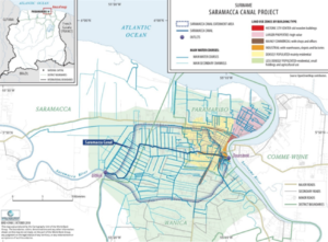
This subcomponent will focus on (i) the rehabilitation of sluices and locks. The project will finance the rehabilitation of two ship locks, each at the outlets of the Saramacca and Suriname Rivers, as well as the five-door sluice gate at the outlet to Suriname River and the four-door sluice gate at the outlet to Saramacca River. This will be the first activity to be undertaken under Component 1 so that water levels in the canal can be adequately managed while the other work components are carried out. (ii) Increase conveyance and navigation through re-profiling and clearing. The Saramacca Canal will be re-profiled and cleared to remove the earth fill and to increase the navigation capacity of the canal and eliminate hydraulic restrictions. Sediment will also be cleared from the outlets of the secondary canals where they join the Saramacca Canal (up to an approximate distance of 250 m). This activity will also finance the establishment of one or more sediment disposal areas for the management of the dredged material. Non-polluted sediments will be processed for reuse, and polluted sediments will be disposed to a designated location in accordance with environmental safeguards procedures.
Subcomponent 1.2 Upgrading of selected critical secondary or tertiary urban sub-catchment areas with piloting of flood management solutions
Focuses on pilot structural and non-structural interventions on critical areas prone to flooding in the secondary or tertiary sub-catchment drainage systems with possible utilization of green solutions for flood management. During the project, one or two priority flood-prone sections of the urban secondary or tertiary drainage channels feeding the Saramacca Canal will be selected as pilot areas for trialling a selection of local flood management solutions to reduce local flood risk. The pilot areas will be identified using a set of selection criteria (such as flood duration, frequency or impact) that will be defined during the project implementation. A communication strategy will be developed to ensure that local stakeholders who are users and beneficiaries of the project are informed of project activities and are able to engage fully with the process. Several public information events will be held to disseminate information regarding the status of the works and to receive feedback, and various beneficiaries will be consulted.
Component 2 Strengthening the Saramacca Canal Water Management System
Component 2 deals with nonstructural flood management measures. This component will finance technical assistance (TA) activities to improve the capacity of the GoS to manage and operate the Saramacca Canal System, including the Saramacca Canal’s water levels and hydraulic structure operations with the objective of reducing flood risk in the city of Paramaribo and facilitating navigation.
Subcomponent 2.1 Updating of norms and guidelines for drainage management
This subcomponent will update parts of the 2001 Drainage Master Plan and develop and update guidelines and recommendations for efficiently planning and managing the Saramacca Canal drainage area, including drainage Design Standards and Norms/Regulations. Flood risk, hazard maps, and other data will be shared with relevant ministries to inform land use planning strategies within the greater Paramaribo area.
Subcomponent 2.2 Drainage infrastructure asset management platform
This subcomponent focuses on TA, information technology equipment and software, and training to improve the operation, management, and surveillance of the drainage system. An asset management platform for operational management of the Saramacca Canal will be established to ensure optimization of the canal water levels for flood control, navigation, and irrigation purposes during the day-to-day operation of the system, taking into account short-lived, intense rainfall events and longer-term seasonal wet and dry cycles. The operational management and monitoring platform will ensure prioritization of functions (flood control, navigation, and irrigation) based on a flood and drought forecasting system and also define regular monitoring and maintenance activities such as ‘flushing’ of the canal, whereby water is accumulated in the channel and is allowed to disperse rapidly out of the sluices at low tide, clearing floating vegetation and accumulated sediment to allow obstruction-free navigation. The system will also be optimized to allow navigation. In addition, the hydromet data management system will be strengthened and a flood forecasting service developed. Existing hydromet instrumentation will be expanded to provide real-time observations of weather variables and water levels in the Saramacca Canal and main secondary canals. Additional tidal gauges will be installed to monitor water levels of Suriname and Saramacca Rivers in the vicinity of the Saramacca Canal. A flood forecasting system for Paramaribo and the surrounding areas will be developed, which will be driven by the existing weather radar, coupled with the existing and proposed automated rain gauge network, and new and existing tide and water level gauges based on a digitalized inventory of existing drainage and hydromet infrastructure. All available data will be assimilated into a suitable data management platform and used to drive a real-time operational model for the Saramacca Canal.
Subcomponent 2.3 Institutional support toward a possible Saramacca Canal System Platform.
This subcomponent will finance a feasibility study for a possible Saramacca Canal System Platform composed of various stakeholders for the operational and sustainability of the canal. The study will review the requirements for managing the drainage infrastructure asset management system set up under Subcomponent 2.1, explore options for setting up and running a steering committee or management platform, and review the recommendations made in the 2001 Master Plan for the establishment of a drainage authority. The Platform (or similar institution) will be responsible for ensuring the sustainability of the drainage system and the day-to-day operational management of the Saramacca Canal. This subcomponent will also consider cost recovery mechanisms, which may include the introduction of navigation tariffs, ensuring the financial sustainability of the system. This subcomponent will also review organizational roles and responsibilities related to drainage and irrigation and the communication and cooperation procedures between the various agencies.
Component 3 Providing a Contingent Emergency Response
This component will include a contingent emergency response component to respond rapidly at the Government’s request in the event of a natural disaster. This component will finance the implementation of emergency works, rehabilitation, and associated assessments and will be available to respond rapidly at the Government’s request in the event of a natural disaster.
Component 4 Supporting the Project Management and Implementation Support
This component will support the costs related to the overall project management and implementation support.
Map